
TENO2 : Tenkiller Lake
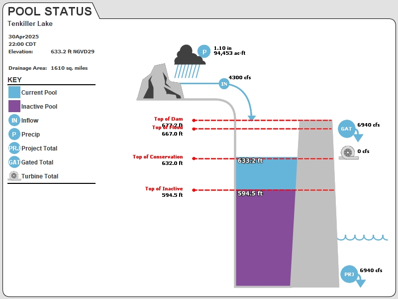
Current Readings
- 2.25 ft ABOVE normal
- Pool elevation is 634.25 feet on 14JUL2025 16:00 hours.
- At this elevation the total amount of water stored in Tenkiller Lake is 698444 acre-feet.
- Reservoir release is 4539 cubic feet per second on Monday 14Jul2025 15:00.
- Flood pool is 5.3% full.
- Flood pool storage filled is 30253 acre-feet which is equivalent to 0.35 inches of runoff over the entire drainage basin.
- Flood pool storage empty is 540139 acre-feet which is equivalent to 6.29 inches of runoff over the entire drainage basin.
Gate Change
Conditions at the time of Gate Change- Monday, 14 Jul 2025 0930
- Pool Elevation = 634.30 feet.
- Total Release = 4540 (cfs)
- Gate Release = 4540 (cfs)
- Turbine Release = 0 (cfs)
- Gate Settings:
- 1 Conduit Gates open 3.5 FT
- 1 Conduit Gates open 4.0 FT
Evaporation Data
- 0.174 inches - 14JUL2025 @ 07:00
Reservoir Data
| Elevation | Incremental Storage | Cumulative Storage | |||
|---|---|---|---|---|---|
| (feet) | (inches of runoff)* | (acre-feet) | (inches of runoff)* | (acre-feet) | |
| Surcharge Pool: | 671.00 | 0.99 | 84617 | 15.41 | 1323200 |
| Flood Control Pool: | 667.00 | 6.64 | 570392 | 14.42 | 1238583 |
| Conservation Pool: | 632.00 | 4.30 | 369087 | 7.78 | 668190 |
| Inactive Pool: | 594.50 | 3.48 | 299103 | 3.48 | 299103 |
Streambed Elevation: 480.20 feet.
Top of Dam Elevation: 677.20 feet.
* Values in the above "inches of runoff" column are based on a contributing drainage area of 1610.0 square miles.
Longitude: -95° 2' 57 Latitude: 35° 35' 48
Map of Tenkiller Lake Dam
Links for More Information
Graphs
of Measured and Calculated Lake Parameters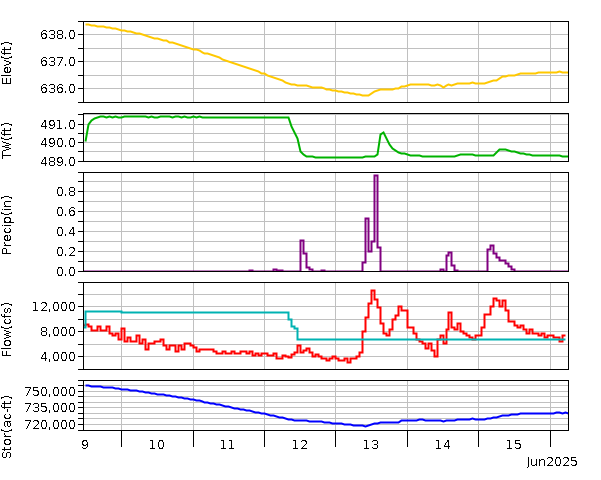
Tenkiller Ferry Lake near Gore, OK
Go to Tulsa District Water Control Home Page.
Disclaimer:These pages are subject to change.Last Page Update: Monday, 14 Jul 2025 16:32