
MYST2 : Pat Mayse Lake
Current Readings
- 1.82 ft BELOW normal
- Pool elevation is 449.18 feet on 04MAY2026 01:00 hours.
- At this elevation the total amount of water stored in Pat Mayse Lake is 102600 acre-feet.
- Reservoir release is 0 cubic feet per second on Monday 04May2026 01:00.
- Conservation pool is 91.05% full.
- Conservation pool storage filled is 99680 acre-feet which is equivalent to 10.68 inches of runoff over the entire drainage basin.
- Conservation pool storage empty is 9797 acre-feet which is equivalent to 1.05 inches of runoff over the entire drainage basin.
Gate Change
Conditions at the time of Gate Change- Saturday, 30 Sep 2017 1200
- Pool Elevation = 451.02 feet.
- Total Release = 1 (cfs)
- Gate Release = 0 (cfs)
- Unregulated Release = 1 (cfs)
- Auxillary Unregulated Release = 0 (cfs)
- Gate Settings:
- All CLOSED
Evaporation Data
- 0.465 inches - 04MAY2026 @ 07:00
Reservoir Data
| Elevation | Incremental Storage | Cumulative Storage | |||
|---|---|---|---|---|---|
| (feet) | (inches of runoff)* | (acre-feet) | (inches of runoff)* | (acre-feet) | |
| Surcharge Pool: | ---- | ---- | ---- | ---- | ---- |
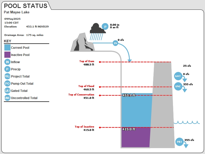
| Flood Control Pool: | 460.50 | 6.75 | 63040 | 18.79 | 175437 |
| Conservation Pool: | 451.00 | 11.73 | 109477 | 12.04 | 112397 |
| Inactive Pool: | 415.00 | 0.31 | 2919 | 0.31 | 2919 |
Streambed Elevation: 392.50 feet.
Top of Dam Elevation: 488.50 feet.
* Values in the above "inches of runoff" column are based on a contributing drainage area of 175.0 square miles.
Longitude: -95° 32' 38 Latitude: 33° 51' 10
Map of Pat Mayse Lake Dam
Links for More Information
Graphs
of Measured and Calculated Lake Parameters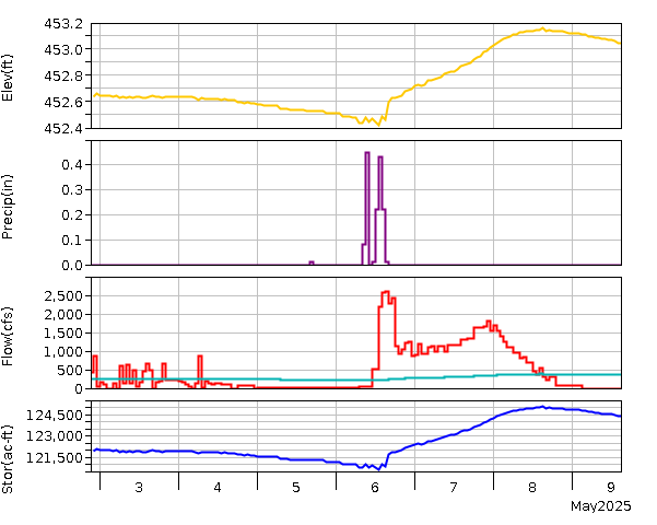
Pat Mayse Lake
Go to Tulsa District Water Control Home Page.
Disclaimer:These pages are subject to change.Last Page Update: Monday, 04 May 2026 02:02