
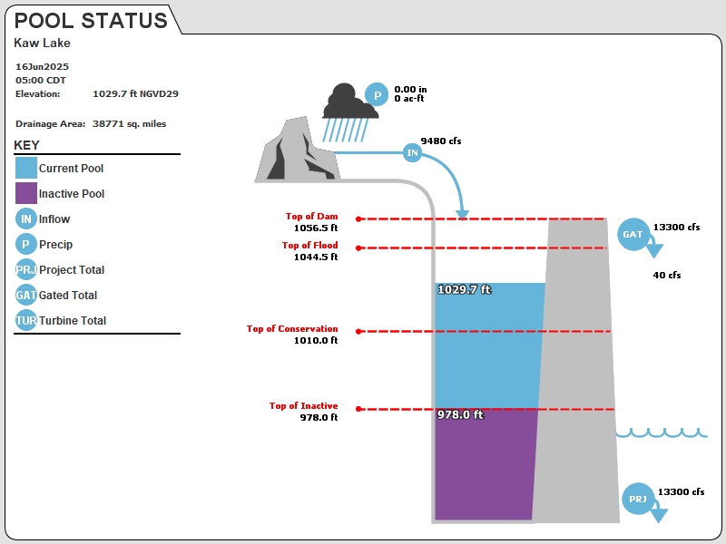
KAWO2 : Kaw Lake
Current Readings
- 14.76 ft ABOVE normal
- Pool elevation is 1024.76 feet on 05JUL2025 17:00 hours.
- At this elevation the total amount of water stored in Kaw Lake is 625062 acre-feet.
- Reservoir release is 8805 cubic feet per second on Saturday 05Jul2025 17:00.
- Flood pool is 32.04% full.
- Flood pool storage filled is 281018 acre-feet which is equivalent to 0.14 inches of runoff over the entire drainage basin.
- Flood pool storage empty is 596041 acre-feet which is equivalent to 0.29 inches of runoff over the entire drainage basin.
Gate Change
Conditions at the time of Gate Change- Wednesday, 02 Jul 2025 0850
- Pool Elevation = 1028.19 feet.
- Total Release = 13557 (cfs)
- Gate Release = 9192 (cfs)
- Turbine Release = 4365 (cfs)
- Gate Settings:
- 3 Tainter Gates open 1.0 FT
- 5 Tainter Gates open 0.5 FT
- 1 Sluice Gates open 3.0 FT
- 1 Sluice Gates open 4.0 FT
Evaporation Data
- 0.112 inches - 05JUL2025 @ 07:00
Reservoir Data
| Elevation | Incremental Storage | Cumulative Storage | |||
|---|---|---|---|---|---|
| (feet) | (inches of runoff)* | (acre-feet) | (inches of runoff)* | (acre-feet) | |
| Surcharge Pool: | 1047.50 | 0.08 | 168997 | 0.67 | 1390100 |
| Flood Control Pool: | 1044.50 | 0.42 | 877059 | 0.59 | 1221102 |
| Conservation Pool: | 1010.00 | 0.14 | 280322 | 0.17 | 344043 |
| Inactive Pool: | 978.00 | 0.03 | 63721 | 0.03 | 63721 |
Streambed Elevation: 931.50 feet.
Top of Dam Elevation: 1056.50 feet.
* Values in the above "inches of runoff" column are based on a contributing drainage area of 38771.0 square miles.
Longitude: -96° 55' 18 Latitude: 36° 41' 58
Map of Kaw Lake Dam
Links for More Information
Graphs
of Measured and Calculated Lake Parameters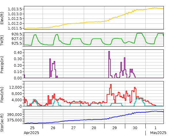
Kaw Lake
Go to Tulsa District Water Control Home Page.
Disclaimer:These pages are subject to change.Last Page Update: Saturday, 05 Jul 2025 18:01