
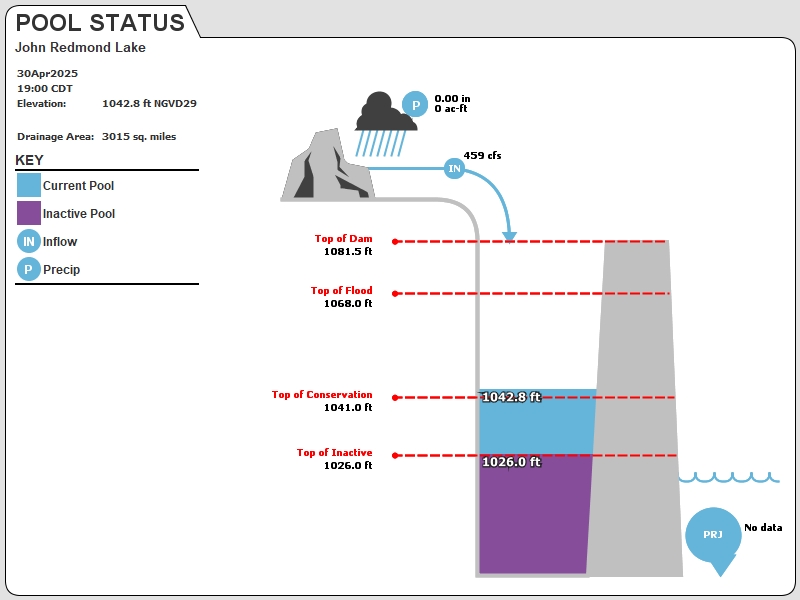
JRLK1 : John Redmond Lake
Current Readings
- 14.42 ft ABOVE normal
- Pool elevation is 1055.42 feet on 01JUL2025 20:00 hours.
- At this elevation the total amount of water stored in John Redmond Lake is 258234 acre-feet.
- Reservoir release is 10401 cubic feet per second on Tuesday 01Jul2025 21:00.
- Flood pool is 38.84% full.
- Flood pool storage filled is 199942 acre-feet which is equivalent to 1.24 inches of runoff over the entire drainage basin.
- Flood pool storage empty is 314866 acre-feet which is equivalent to 1.96 inches of runoff over the entire drainage basin.
Gate Change
Conditions at the time of Gate Change- Monday, 23 Jun 2025 1210
- Pool Elevation = 1062.66 feet.
- Total Release = 11064 (cfs)
- Gate Release = 11064 (cfs)
- Gate Settings:
- 9 Tainter Gates open 1.0 FT
- 5 Tainter Gates open 0.5 FT
- 2 Low Flow Gates open 100.0 PERCENT
Evaporation Data
- 0.281 inches - 01JUL2025 @ 07:00
Reservoir Data
| Elevation | Incremental Storage | Cumulative Storage | |||
|---|---|---|---|---|---|
| (feet) | (inches of runoff)* | (acre-feet) | (inches of runoff)* | (acre-feet) | |
| Surcharge Pool: | 1073.00 | 1.04 | 167248 | 4.60 | 740348 |
| Flood Control Pool: | 1068.00 | 3.20 | 514808 | 3.56 | 573099 |
| Conservation Pool: | 1041.00 | 0.36 | 58248 | 0.36 | 58291 |
| Inactive Pool: | 1026.00 | 0.00 | 43 | 0.00 | 43 |
Streambed Elevation: 995.00 feet.
Top of Dam Elevation: 1081.50 feet.
* Values in the above "inches of runoff" column are based on a contributing drainage area of 3015.0 square miles.
Longitude: -95° 46' 6 Latitude: 38° 14' 12
Map of John Redmond Lake Dam
Links for More Information
Graphs
of Measured and Calculated Lake Parameters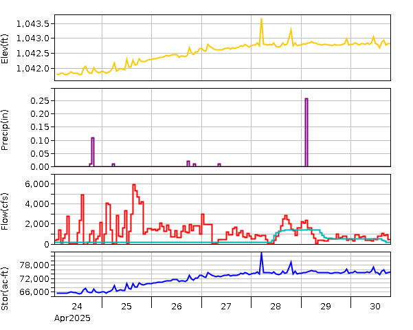
JOHN REDMOND RE NR BURLINGTON, KS
Go to Tulsa District Water Control Home Page.
Disclaimer:These pages are subject to change.Last Page Update: Tuesday, 01 Jul 2025 21:33