
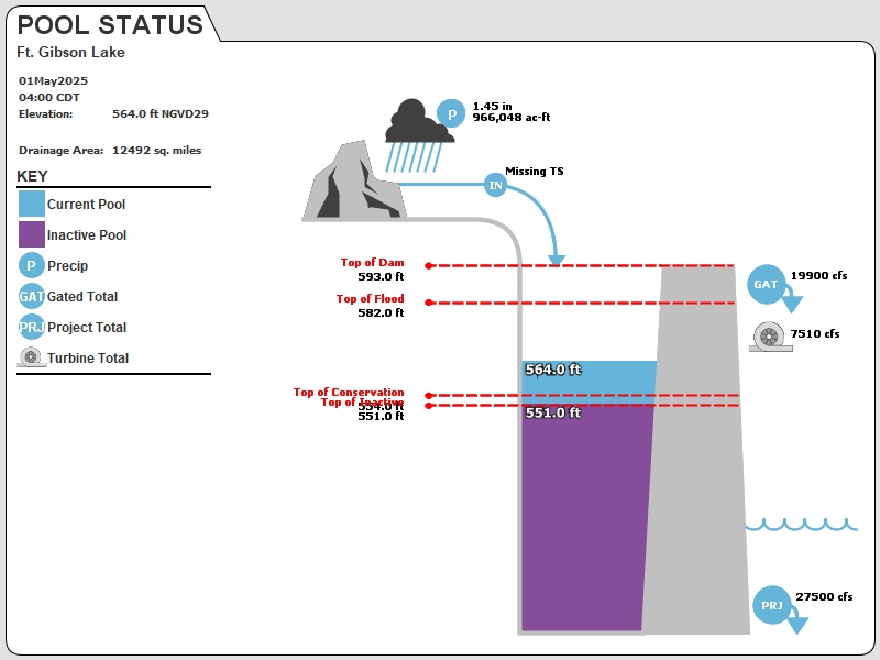
GIBO2 : Ft. Gibson Lake
Current Readings
- 13.90 ft ABOVE normal
- Pool elevation is 567.9 feet on 10JUL2025 18:00 hours.
- At this elevation the total amount of water stored in Ft. Gibson Lake is 708789 acre-feet.
- Reservoir release is 33775 cubic feet per second on Thursday 10Jul2025 18:00.
- Flood pool is 37.38% full.
- Flood pool storage filled is 343589 acre-feet which is equivalent to 0.52 inches of runoff over the entire drainage basin.
- Flood pool storage empty is 575610 acre-feet which is equivalent to 0.86 inches of runoff over the entire drainage basin.
Gate Change
Conditions at the time of Gate Change- Thursday, 10 Jul 2025 0900
- Pool Elevation = 568.65 feet.
- Total Release = 34339 (cfs)
- Gate Release = 24302 (cfs)
- Turbine Release = 10037 (cfs)
- Gate Settings:
- 25 Tainter Gates open 1.0 FT
- 5 Tainter Gates open 0.5 FT
Evaporation Data
- 0.329 inches - 10JUL2025 @ 07:00
Reservoir Data
| Elevation | Incremental Storage | Cumulative Storage | |||
|---|---|---|---|---|---|
| (feet) | (inches of runoff)* | (acre-feet) | (inches of runoff)* | (acre-feet) | |
| Surcharge Pool: | ---- | ---- | ---- | ---- | ---- |
| Flood Control Pool: | 582.00 | 1.38 | 919199 | 1.93 | 1284399 |
| Conservation Pool: | 554.00 | 0.08 | 53899 | 0.55 | 365199 |
| Inactive Pool: | 551.00 | 0.47 | 311300 | 0.47 | 311300 |
Streambed Elevation: 483.00 feet.
Top of Dam Elevation: 593.00 feet.
* Values in the above "inches of runoff" column are based on a contributing drainage area of 12492.0 square miles.
Longitude: -95° 13' 43 Latitude: 35° 52' 16
Map of Ft. Gibson Lake Dam
Links for More Information
Graphs
of Measured and Calculated Lake Parameters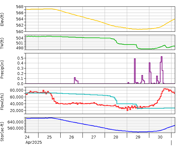
Fort Gibson Lake near Fort Gibson, OK
Go to Tulsa District Water Control Home Page.
Disclaimer:These pages are subject to change.Last Page Update: Thursday, 10 Jul 2025 19:02