
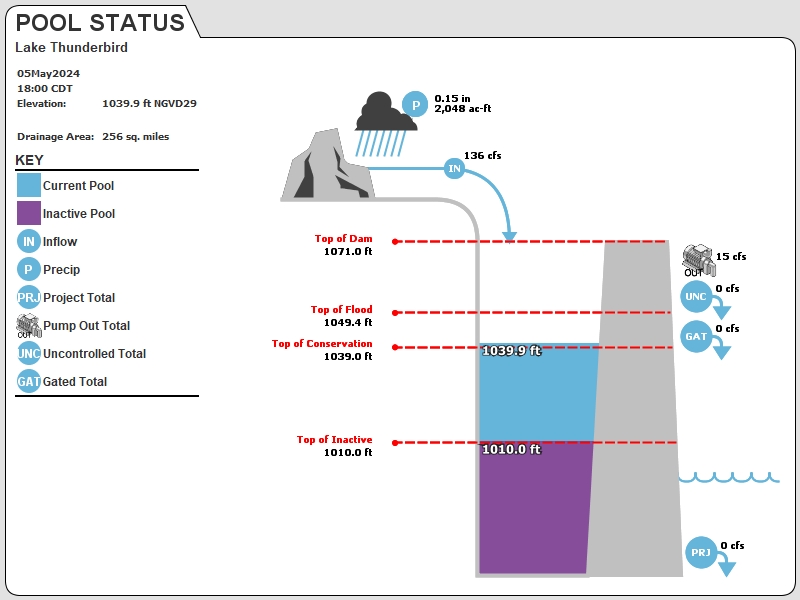
NRMO2 : Lake Thunderbird
Current Readings
- 0.23 ft ABOVE normal
- Pool elevation is 1039.23 feet on 24APR2024 12:00 hours.
- At this elevation the total amount of water stored in Lake Thunderbird is 107207 acre-feet.
- Reservoir release is 0 cubic feet per second on Wednesday 24Apr2024 12:00.
- Flood pool is 1.77% full.
- Flood pool storage filled is 1264 acre-feet which is equivalent to 0.09 inches of runoff over the entire drainage basin.
- Flood pool storage empty is 74988 acre-feet which is equivalent to 5.49 inches of runoff over the entire drainage basin.
Gate Change
Conditions at the time of Gate Change- Monday, 08 Apr 2024 0745
- Pool Elevation = 1039.44 feet.
- Total Release = 0 (cfs)
- Gate Release = 0 (cfs)
- Unregulated Release = 0 (cfs)
- Gate Settings:
- All CLOSED
Evaporation Data
- 0.261 inches - 24APR2024 @ 07:00
Reservoir Data
| Elevation | Incremental Storage | Cumulative Storage | |||
|---|---|---|---|---|---|
| (feet) | (inches of runoff)* | (acre-feet) | (inches of runoff)* | (acre-feet) | |
| Surcharge Pool: | ---- | ---- | ---- | ---- | ---- |
| Flood Control Pool: | 1049.40 | 5.58 | 76252 | 13.34 | 182195 |
| Conservation Pool: | 1039.00 | 6.86 | 93670 | 7.76 | 105942 |
| Inactive Pool: | 1010.00 | 0.90 | 12272 | 0.90 | 12272 |
Streambed Elevation: 970.00 feet.
Top of Dam Elevation: 1071.00 feet.
* Values in the above "inches of runoff" column are based on a contributing drainage area of 256.0 square miles.
Longitude: -97° 13' 3.1 Latitude: 35° 13' 24.25
Map of Lake Thunderbird Dam
Links for More Information
Graphs
of Measured and Calculated Lake Parameters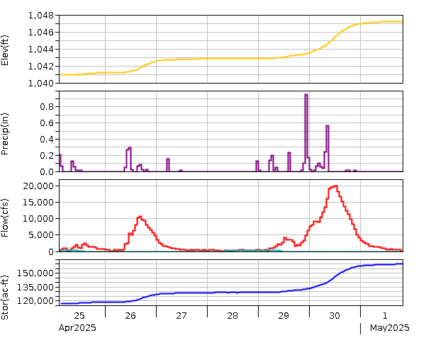
Lake Thunderbird near Norman, OK
Go to Tulsa District Water Control Home Page.
Disclaimer:These pages are subject to change.Last Page Update: Wednesday, 24 Apr 2024 13:02