
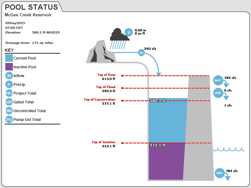
MGCO2 : McGee Creek Reservoir
Current Readings
- 0.05 ft ABOVE normal
- Pool elevation is 577.15 feet on 19APR2024 12:00 hours.
- At this elevation the total amount of water stored in McGee Creek Reservoir is 114158 acre-feet.
- Reservoir release is 11 cubic feet per second on Friday 19Apr2024 12:00.
- Flood pool is 0.23% full.
- Flood pool storage filled is 192 acre-feet which is equivalent to 0.02 inches of runoff over the entire drainage basin.
- Flood pool storage empty is 85230 acre-feet which is equivalent to 9.35 inches of runoff over the entire drainage basin.
Gate Change
Conditions at the time of Gate Change- Wednesday, 17 Apr 2024 1500
- Pool Elevation = 577.16 feet.
- Total Release = 11 (cfs)
- Gate Release = 11 (cfs)
- Unregulated Release = 0 (cfs)
- Gate Settings:
- 1 Low Flow Gates open 43.0 PERCENT
Evaporation Data
- 0.157 inches - 19APR2024 @ 07:00
Reservoir Data
| Elevation | Incremental Storage | Cumulative Storage | |||
|---|---|---|---|---|---|
| (feet) | (inches of runoff)* | (acre-feet) | (inches of runoff)* | (acre-feet) | |
| Surcharge Pool: | ---- | ---- | ---- | ---- | ---- |
| Flood Control Pool: | 595.50 | 9.37 | 85422 | 21.86 | 199388 |
| Conservation Pool: | 577.10 | 11.84 | 108013 | 12.49 | 113966 |
| Inactive Pool: | 515.10 | 0.65 | 5953 | 0.65 | 5953 |
Streambed Elevation: 461.00 feet.
Top of Dam Elevation: 613.50 feet.
* Values in the above "inches of runoff" column are based on a contributing drainage area of 171.0 square miles.
Longitude: -95° 52' 30.94 Latitude: 34° 18' 54.35
Map of McGee Creek Reservoir Dam
Links for More Information
Graphs
of Measured and Calculated Lake Parameters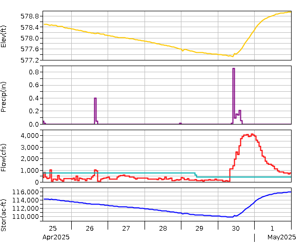
McGee Creek Reservoir near Farris, OK
Go to Tulsa District Water Control Home Page.
Disclaimer:These pages are subject to change.Last Page Update: Friday, 19 Apr 2024 13:02