CAYO2 : Caney Levee
Current Readings:
- Reservoir release is not currently available.
- Conservation pool is 0.00% full.
- Conservation storage filled is 0 acre-feet which is equivalent to -0.00 inches of runoff over the entire drainage basin.
- Conservation storage empty is 0 acre-feet which is equivalent to -0.00 inches of runoff over the entire drainage basin.
Gate Changes:
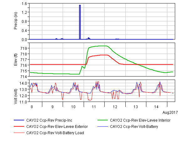
- No Gate Changes have been made in the last 4 days.
Reservoir Data:

| Elevation | Incremental Storage | Cumulative Storage | |||
|---|---|---|---|---|---|
| (feet) | (inches) | (acre-feet) | (inches) | (acre-feet) | |
| Surcharge Pool: | ---- | ---- | ---- | ---- | ---- |
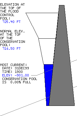
| Flood Control Pool: | 725.40 | -0.01 | 534 | -0.01 | 534 |
| Conservation Pool: | 716.50 | -0.00 | 0 | -0.00 | 0 |
| Inactive Pool: | 716.50 | -0.00 | 0 | -0.00 | 0 |
Streambed Elevation: 717.70 feet.
Top of Dam Elevation: 742.50 feet.
All storages based on a contributing drainage area of -901 square miles.
Total drainage area for the lake is -901 square miles (including upstream projects).
Longitude: 95° 56' 44" Latitude: 36° 59' 57"