
ALTO2 : Altus Lake
Current Readings
- 16.04 ft BELOW normal
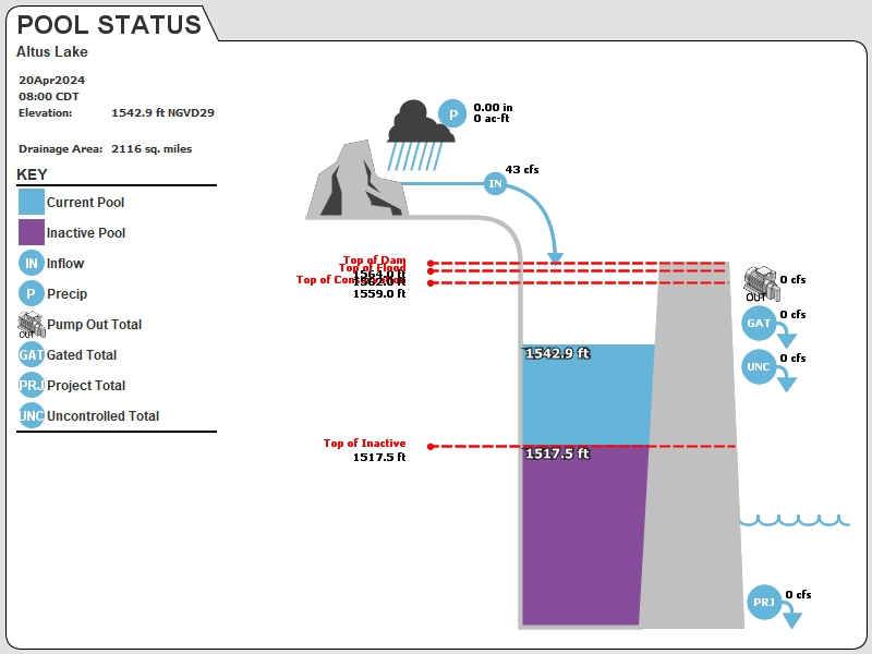
- Pool elevation is 1542.96 feet on 23APR2024 19:00 hours.
- At this elevation the total amount of water stored in Altus Lake is 53333 acre-feet.
- Reservoir release is 0 cubic feet per second on Tuesday 23Apr2024 19:00.
- Conservation pool is 41.29% full.
- Conservation pool storage filled is 52795 acre-feet which is equivalent to 0.47 inches of runoff over the entire drainage basin.
- Conservation pool storage empty is 75490 acre-feet which is equivalent to 0.67 inches of runoff over the entire drainage basin.
Gate Change
Conditions at the time of Gate Change- Saturday, 29 Jun 2019 0945
- Pool Elevation = 1559.20 feet.
- Total Release = 28 (cfs)
- Gate Release = 0 (cfs)
- Unregulated Release = 28 (cfs)
- Gate Settings:
- All CLOSED
Evaporation Data
- 0.329 inches - 23APR2024 @ 07:00
Reservoir Data
| Elevation | Incremental Storage | Cumulative Storage | |||
|---|---|---|---|---|---|
| (feet) | (inches of runoff)* | (acre-feet) | (inches of runoff)* | (acre-feet) | |
| Surcharge Pool: | ---- | ---- | ---- | ---- | ---- |
| Flood Control Pool: | 1562.00 | 0.17 | 19626 | 1.32 | 148545 |
| Conservation Pool: | 1559.00 | 1.14 | 128285 | 1.15 | 128918 |
| Inactive Pool: | 1517.50 | 0.01 | 632 | 0.01 | 632 |
Streambed Elevation: 1471.81 feet.
Top of Dam Elevation: 1564.00 feet.
* Values in the above "inches of runoff" column are based on a contributing drainage area of 2116.0 square miles.
Longitude: -99° 17' 47 Latitude: 34° 53' 15
Map of Altus Lake Dam
Links for More Information
Graphs
of Measured and Calculated Lake Parameters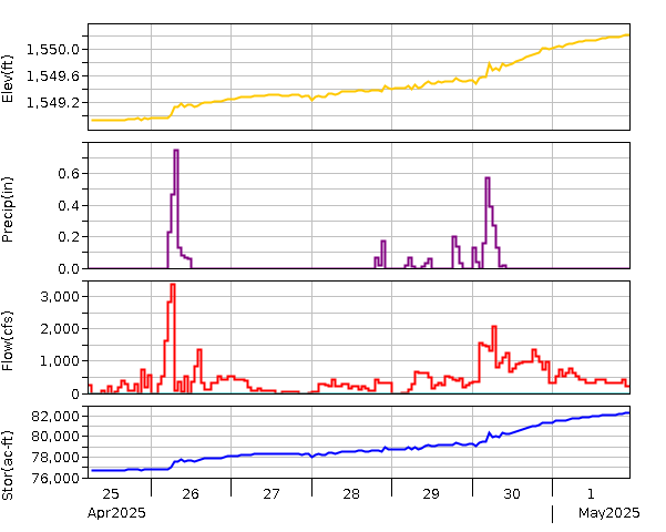
Lake Altus at Lugert, OK
Go to Tulsa District Water Control Home Page.
Disclaimer:These pages are subject to change.Last Page Update: Tuesday, 23 Apr 2024 20:33